Brian Blaylock
December 18, 2020
🌎 ABI Geostationary field-of-view in Cartopy#
-
Full Disk Coverage: Defined as a 17.4 degree diameter circle (pg 48)
[1]:
from datetime import datetime
import cartopy.crs as ccrs
import matplotlib.pyplot as plt
from shapely.geometry import Point
import numpy as np

from goes2go.data import goes_latest, goes_nearesttime

from BB_maps.add_to_cartopy import common_features, pc
WARNING! No module named 'dask'
Without dask, you cannot use dask for multiprocessing.
/p/home/blaylock/BB_python/Carpenter_Workshop/toolbox/cartopy_tools.py:33: UserWarning: No module named 'geopandas' Without geopandas, you cannot subset some NaturalEarthFeatures, like "Major Highways" from roads.
  warnings.warn(
[2]:
# Testing Phase
gcentral = goes_nearesttime(datetime(2017, 10, 5), satellite="G16", product="ABI")

# GOES East
g16 = goes_latest(satellite="G16", product="ABI")

# GOES West
g17 = goes_latest(satellite="G17", product="ABI")
 _______________________________
 | Satellite: noaa-goes16      |
 |   Product: ABI-L2-MCMIPC    |
 |    Domain: C                |
📦 Finished downloading [1] files to [/p/cwfs/blaylock/data/noaa-goes16/ABI-L2-MCMIPC].
📚 Finished reading [1] files into xarray.Dataset.
 _______________________________
 | Satellite: noaa-goes16      |
 |   Product: ABI-L2-MCMIPC    |
 |    Domain: C                |
📦 Finished downloading [1] files to [/p/cwfs/blaylock/data/noaa-goes16/ABI-L2-MCMIPC].
📚 Finished reading [1] files into xarray.Dataset.
 _______________________________
 | Satellite: noaa-goes17      |
 |   Product: ABI-L2-MCMIPC    |
 |    Domain: C                |
📦 Finished downloading [1] files to [/p/cwfs/blaylock/data/noaa-goes17/ABI-L2-MCMIPC].
📚 Finished reading [1] files into xarray.Dataset.
Get the data’s coordinate reference system and field of view with the goes2go.tools.field_of_view function#
This returns both the field of view as a shapely polygon and the cartopy coordinate reference system.
[3]:
g16.FOV.crs
[3]:
<cartopy.crs.Geostationary object at 0x2b5eb637b400>
[4]:
g16.FOV.full_disk # See, the FOV is just a shapely polygon
[4]:

[5]:
g16.FOV.domain # See the FOV for the ABI product domain (CONUS)
[5]:

[9]:
ax = common_features(
OCEAN=True,
LAND=True,
crs=ccrs.PlateCarree(central_longitude=-100),
figsize=[10, 5],
dark=True,
)
# Draw boundary of GOES17
ax.add_geometries(
[g17.FOV.full_disk],
crs=g17.FOV.crs,
facecolor="tab:purple",
edgecolor="k",
alpha=0.3,
linewidth=3,
)
ax.add_geometries(
[g17.FOV.full_disk],
crs=g17.FOV.crs,
facecolor="none",
edgecolor="tab:purple",
alpha=1,
linewidth=3,
zorder=10,
)
# Draw boundary of GOES16
ax.add_geometries(
[g16.FOV.full_disk],
crs=g16.FOV.crs,
facecolor="tab:green",
edgecolor="k",
alpha=0.3,
linewidth=3,
)
ax.add_geometries(
[g16.FOV.full_disk],
crs=g16.FOV.crs,
facecolor="none",
edgecolor="tab:green",
alpha=1,
linewidth=3,
zorder=10,
)
# Draw boundary of GOES-Central (test phase)
ax.add_geometries(
[gcentral.FOV.full_disk],
crs=gcentral.FOV.crs,
facecolor="none",
edgecolor="k",
alpha=0.4,
linewidth=3,
linestyle="--",
zorder=11,
)
ax.text(
g17.geospatial_lat_lon_extent.geospatial_lon_nadir - 90,
g17.geospatial_lat_lon_extent.geospatial_lat_nadir,
"GOES-West",
transform=pc,
rotation=90,
va="center",
fontsize=15,
color="tab:purple",
fontweight="bold",
)
ax.text(
g16.geospatial_lat_lon_extent.geospatial_lon_nadir + 80,
g16.geospatial_lat_lon_extent.geospatial_lat_nadir,
"GOES-East",
transform=pc,
rotation=-90,
va="center",
fontsize=15,
color="tab:green",
fontweight="bold",
)
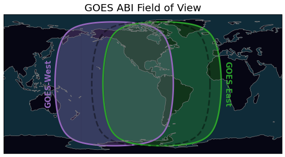
plt.title("GOES ABI Field of View", fontsize=20)
plt.savefig("../images/ABI_field-of-view.png")
plt.savefig("../docs/_static/ABI_field-of-view.png")
[10]:
ax = common_features(
OCEAN=True,
LAND=True,
crs=ccrs.PlateCarree(central_longitude=-100),
figsize=[10, 5],
dark=True,
)
ax.add_geometries(
[g16.FOV.full_disk],
crs=g16.FOV.crs,
facecolor="tab:purple",
edgecolor="tab:purple",
alpha=0.3,
linewidth=3,
)
ax.add_geometries(
[g16.FOV.domain],
crs=g16.FOV.crs,
facecolor="tab:green",
edgecolor="tab:green",
alpha=0.3,
linewidth=3,
)
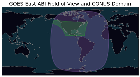
plt.title("GOES-East ABI Field of View and CONUS Domain", fontsize=20)
plt.savefig("../docs/_static/ABI_field-of-view_16dom.png")
[11]:
ax = common_features(
OCEAN=True,
LAND=True,
crs=ccrs.PlateCarree(central_longitude=-100),
figsize=[10, 5],
dark=True,
)
ax.add_geometries(
[g17.FOV.full_disk],
crs=g17.FOV.crs,
facecolor="tab:purple",
edgecolor="tab:purple",
alpha=0.3,
linewidth=3,
)
ax.add_geometries(
[g17.FOV.domain],
crs=g17.FOV.crs,
facecolor="tab:green",
edgecolor="tab:green",
alpha=0.3,
linewidth=3,
)
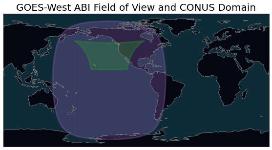
plt.title("GOES-West ABI Field of View and CONUS Domain", fontsize=20)
plt.savefig("../docs/_static/ABI_field-of-view_17dom.png")
[15]:
crs_16.proj4_params
[15]:
{'a': 6378137.0,
 'b': 6356752.31414,
 'rf': 298.2572221,
 'proj': 'geos',
 'lon_0': -75.0,
 'lat_0': 0.0,
 'h': 35786023.0,
 'x_0': 0,
 'y_0': 0,
 'units': 'm',
 'sweep': 'x'}
[16]:
crs_central.proj4_params
[16]:
{'a': 6378137.0,
 'b': 6356752.31414,
 'rf': 298.2572221,
 'proj': 'geos',
 'lon_0': -89.5,
 'lat_0': 0.0,
 'h': 35786023.0,
 'x_0': 0,
 'y_0': 0,
 'units': 'm',
 'sweep': 'x'}
[17]:
crs_17.proj4_params
[17]:
{'a': 6378137.0,
 'b': 6356752.31414,
 'rf': 298.2572221,
 'proj': 'geos',
 'lon_0': -137.0,
 'lat_0': 0.0,
 'h': 35786023.0,
 'x_0': 0,
 'y_0': 0,
 'units': 'm',
 'sweep': 'x'}
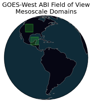
[13]:
M1 = goes_latest(domain="M1")
M2 = goes_latest(domain="M2")
ax = common_features(
OCEAN=True,
LAND=True,
crs=ccrs.PlateCarree(central_longitude=-100),
figsize=[10, 5],
dark=True,
)
ax.add_geometries(
[M1.FOV.full_disk],
crs=M1.FOV.crs,
facecolor="tab:purple",
edgecolor="tab:purple",
alpha=0.3,
linewidth=3,
)
ax.add_geometries(
[M1.FOV.domain],
crs=M1.FOV.crs,
facecolor="tab:green",
edgecolor="tab:green",
alpha=0.3,
linewidth=3,
)
ax.add_geometries(
[M2.FOV.domain],
crs=M2.FOV.crs,
facecolor="tab:green",
edgecolor="tab:green",
alpha=0.3,
linewidth=3,
)
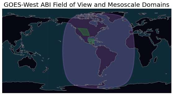
plt.title("GOES-West ABI Field of View and Mesoscale Domains", fontsize=20)
plt.savefig("../docs/_static/ABI_field-of-view_16M1M2.png")
 _______________________________
 | Satellite: noaa-goes16      |
 |   Product: ABI-L2-MCMIPM    |
 |    Domain: M1               |
📦 Finished downloading [1] files to [/p/cwfs/blaylock/data/noaa-goes16/ABI-L2-MCMIPM].
📚 Finished reading [1] files into xarray.Dataset.
 _______________________________
 | Satellite: noaa-goes16      |
 |   Product: ABI-L2-MCMIPM    |
 |    Domain: M2               |
📦 Finished downloading [1] files to [/p/cwfs/blaylock/data/noaa-goes16/ABI-L2-MCMIPM].
📚 Finished reading [1] files into xarray.Dataset.
/p/home/blaylock/anaconda3/envs/goes2go/lib/python3.8/site-packages/cartopy/mpl/feature_artist.py:154: UserWarning: Unable to determine extent. Defaulting to global.
  warnings.warn('Unable to determine extent. Defaulting to global.')
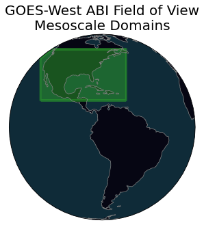
[16]:
M1 = goes_latest(domain="M1")
M2 = goes_latest(domain="M2")

ax = common_features(OCEAN=True, LAND=True, crs=M1.FOV.crs, figsize=[10, 5], dark=True)


ax.add_geometries(
    [M1.FOV.domain],
    crs=M1.FOV.crs,
    facecolor="tab:green",
    edgecolor="tab:green",
    alpha=0.3,
    linewidth=3,
)
ax.add_geometries(
    [M2.FOV.domain],
    crs=M2.FOV.crs,
    facecolor="tab:green",
    edgecolor="tab:green",
    alpha=0.3,
    linewidth=3,
)

plt.title("GOES-West ABI Field of View\nMesoscale Domains", fontsize=20)

plt.savefig("../docs/_static/ABI_field-of-view_16M1M2_geo.png")
 _______________________________
 | Satellite: noaa-goes16      |
 |   Product: ABI-L2-MCMIPM    |
 |    Domain: M1               |
📦 Finished downloading [1] files to [/p/cwfs/blaylock/data/noaa-goes16/ABI-L2-MCMIPM].
📚 Finished reading [1] files into xarray.Dataset.
 _______________________________
 | Satellite: noaa-goes16      |
 |   Product: ABI-L2-MCMIPM    |
 |    Domain: M2               |
📦 Finished downloading [1] files to [/p/cwfs/blaylock/data/noaa-goes16/ABI-L2-MCMIPM].
📚 Finished reading [1] files into xarray.Dataset.
[21]:
ax = common_features(OCEAN=True, LAND=True, crs=g16.FOV.crs, figsize=[10, 5], dark=True)


ax.add_geometries(
    [g16.FOV.domain],
    crs=g16.FOV.crs,
    facecolor="tab:green",
    edgecolor="tab:green",
    alpha=0.3,
    linewidth=3,
)
ax.add_geometries(
    [g16.FOV.domain],
    crs=g16.FOV.crs,
    facecolor="tab:green",
    edgecolor="tab:green",
    alpha=0.3,
    linewidth=3,
)

plt.title("GOES-West ABI Field of View\nMesoscale Domains", fontsize=20)

plt.savefig("../docs/_static/ABI_field-of-view_16_geo.png")
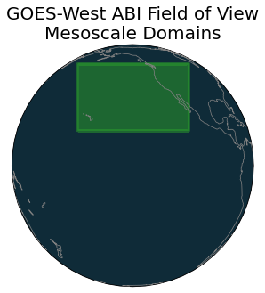
[24]:
ax = common_features(OCEAN=True, LAND=True, crs=g17.FOV.crs, figsize=[10, 5], dark=True)


ax.add_geometries(
    [g17.FOV.domain],
    crs=g17.FOV.crs,
    facecolor="tab:green",
    edgecolor="tab:green",
    alpha=0.3,
    linewidth=3,
)
ax.add_geometries(
    [g17.FOV.domain],
    crs=g17.FOV.crs,
    facecolor="tab:green",
    edgecolor="tab:green",
    alpha=0.3,
    linewidth=3,
)

plt.title("GOES-West ABI Field of View\nMesoscale Domains", fontsize=20)

plt.savefig("../docs/_static/ABI_field-of-view_17_geo.png")
[ ]: